
- Видео 436
- Просмотров 419 679
Victoria Air Photos and Survey
Канада
Добавлен 11 апр 2013
Aerial drone shots and survey. We show real estate drone footage, 4K clips, training videos, and safety considerations with drones in airspace in Canada. Victoria Air Photos and Survey also has drone footage of cities and parks as well as land marks. Free training videos are located under the training page
Drone LiDAR with BC Land Survey
Working with Powell and Associates Land Surveyors, we have been able to showcase high quality deliverables for clients.
Pointclouds from LiDAR are much more dense and accurate for data analytics than photogrammetry applications. The workflow is more efficient and saves on processing times and costs.
#pointcloud #lidar #dronesurvey
Pointclouds from LiDAR are much more dense and accurate for data analytics than photogrammetry applications. The workflow is more efficient and saves on processing times and costs.
#pointcloud #lidar #dronesurvey
Просмотров: 44
Видео


Why hire us for LiDAR land survey rather than photos/photogrammetry?
Просмотров 66Месяц назад
This video explains why you would want to call us and use our LiDAR L2 as opposed to typical, off-the-shelf drones for land survey and other photogrammetry applications. Accuracy is critically important as a industry standard. With 10 years of experience in drone survey application, we have the right skills to get your project done 100%. Moreover our survey data is verified by a qualified BC La...

How the SUV fits into our RPAS operations :)
Просмотров 832 месяца назад
New video explains why the SUV was the best fit for our business and how it will greatly expand our reach into off road areas such as logging roads, utility service areas and so on. Reliability is key and this vehicle has the power to tow up to 3500 lbs and charge our UAV batteries when we are working in sparsely settled areas with no electric power available. With this new vehicle we plan to b...

Saanichton Peninsula Hospital to Marigold Lands and Pat Bay Highway
Просмотров 122 месяца назад
M300 and P1 shot of the Saancihton Peninsula in HD with Full framed 45 Camera. Contact us for aerial photos and video call.whatsapp.com/video/FYjQe9UBR2zSoTciso6Bdlvictoriaairphotos.com/surveying-.html

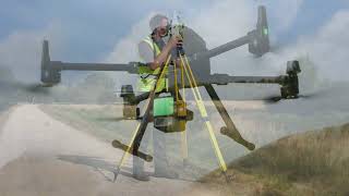
Victoria Air Photos and Survey Drone LiDAR for Land Survey
Просмотров 3162 месяца назад
Contact VAP to book your land survey project today using our new system. Visit our webpage at victoriaairphotos.com/lidar-scans.html or call David directly at 250 507 6421 We feature the pro quality DJI ZP1 RTK full-framed survey camera and the DJI L2 LiDAR with up to 5 returns and a demonstrated 2CM relative accuracies on projects. Drone LiDAR for topographic surveys using VAP will greatly enh...

L2 Promo Condenssed Promotion
Просмотров 393 месяца назад
Hire us to get LiDAR working for your next project. This is the next phase of drone survey capability. As this drone technology advances. You never want to be left behind in practice. victoriaairphotos.com/lidar-scans.html #lidar #lidarscanner #dronesurvey #droneshots

Stock Video Clips of Victoria and Area
Просмотров 443 месяца назад
4 K footage of the city of Victoria and area. Call for a quote and get your RAW unedited clips today:) victoriaairphotos.com/stock_photography.html
VAP using the new L2 LiDAR for topographic survey. LiDAR drone for hire
Просмотров 4,1 тыс.4 месяца назад
Victoria Air Photos and Survey is a drone service provider since 2013. VAP is located in Saanichton, South Vancouver Island, BC. Professional Land Surveyors have shown relative accuracies of tighter than 2.5 cm consistently on drone projects completed and processed. This proves we can make reliable survey grade topographical surveys. Visit our webpage. victoriaairphotos.com/lidar-scans.html . I...

Bear Mountain Langford development with vista views 4K Drone clip
Просмотров 695 месяцев назад
Full frame 4K video footage taken on Bear Mountain Westview development sites. Footage by VAP
Full Framed Camera... Note the differences in drone camera quality? my Mavic could not come close
Просмотров 806 месяцев назад
Typical drone cameras 9 (DJI Mini, Mavic's. Phantom 4) even at a 1 inch (or less) sensors and will therefore have lens distortions, untrue color, pixilation, noise and so on. With this unedited clip, we can see unadulterated imagery from a full framed 45MP ZP1 camera and the quality.
Lesson 1 Intro/ Buttonville Airport Drone Collision
Просмотров 3556 месяцев назад
Part one of a lesson series on the TSB accident investigation
Part 2 Buttonville Drone Crash TBS Investigation. How much worse could the accident have been?
Просмотров 2,6 тыс.6 месяцев назад
How much worse could have drone collision with an aircraft been? Video and lessons learned. Take our online drone safety course herewww.udemy.com/course/rpassafteyintro/?referralCode=BF77DC3867743F48FFAD DJI has attempted to mitigate collision hazards with geo fence solutions. In this accident, it failed to prevent the occurrence. Some of DJIs action do not help safety such as offering a free r...
DJI Mavic 2EA. Near crash with hydro line
Просмотров 1016 месяцев назад
Note the obstacle avoidance sensors did not prevent this situation? The drone needed proper Visual Observer communication which was not there. Take our online drone safety course herewww.udemy.com/course/rpassafteyintro/?referralCode=BF77DC3867743F48FFAD The pilot flying apparently did not see the power lines as a threat based on the position and height of the drone above ground level and came ...
TSB Accident Investigation Part 5 A Criminal Code for Unsafe Aircraft Operations
Просмотров 1276 месяцев назад
This is part 5A of our TSB accident investigation lecture by Drone Pilot and Flight Reviewer Instructor David Carlos. We go over safety analytics concerning an actual collision between a commercial drone and a manned aircraft at Buttonville Airport. The purpose of this investigation is to learn from critical mistakes, not repeat them and assess the risk of drones integration in our airspace. Ta...
Thermal Investigation Drone Operation
Просмотров 1606 месяцев назад
Thermal Investigation Drone Operation
Lesson Part 4: Task Saturation with Drone Services? TSB Crash Investigation Analysis
Просмотров 1656 месяцев назад
Lesson Part 4: Task Saturation with Drone Services? TSB Crash Investigation Analysis
VAP Photogrammetry Results and Comparison
Просмотров 1959 месяцев назад
VAP Photogrammetry Results and Comparison
LIDAR Workflow and Process with YS Mapper Plus and M300 Multi-Rotor
Просмотров 2089 месяцев назад
LIDAR Workflow and Process with YS Mapper Plus and M300 Multi-Rotor
Bridge, tower and infrastructure coating inspection services by drone
Просмотров 2119 месяцев назад
Bridge, tower and infrastructure coating inspection services by drone
MV Atlantic Condor and DFO Ready for Mission to Deep Sea to Find Illegal Fishing. First of it's Kind
Просмотров 47110 месяцев назад
MV Atlantic Condor and DFO Ready for Mission to Deep Sea to Find Illegal Fishing. First of it's Kind
VAP LIDAR RPAS/UAV Flight and Data Processing Workflows for Survey
Просмотров 11011 месяцев назад
VAP LIDAR RPAS/UAV Flight and Data Processing Workflows for Survey
Yates at Douglas Victoria Drone Video
Просмотров 5311 месяцев назад
Yates at Douglas Victoria Drone Video
Active Pass with Seaspan Transporter Motor Vessel
Просмотров 195Год назад
Active Pass with Seaspan Transporter Motor Vessel
Stealth Bomber F117 at Psalm Springs Air museum
Просмотров 90Год назад
Stealth Bomber F117 at Psalm Springs Air museum
Are you sure you're complying with all legal aspects? the 100 mtr rule for buildngs and vehicles seem to be being breached in your video.
ruclips.net/video/MDiPs3MvKkc/видео.html Check out how close this drone gets to the power lines while in Active Track. The end is the craziest part.
How’s the battery monitor? On mine it can read one or two bars, but it still be blue on the battery. I get very erroneous readings.
Not bad. IT does reflect reality for the most part. I tr and deep cycle it regularly
Drones for land survey applications ruclips.net/video/JBFv4TUjZKk/видео.htmlsi=ny7gfLSV9RsMZyh4 LiDAR equipment
See our drones for land survey applications ruclips.net/video/JBFv4TUjZKk/видео.htmlsi=ny7gfLSV9RsMZyh4
Hire us for LiDAR land survey work. ruclips.net/video/JBFv4TUjZKk/видео.htmlsi=ny7gfLSV9RsMZyh4
Why does the emissivity indicate water penetration? Could this also just not indicate poor insulation with a sealed water tight membrane?
Like bottled water, water holds heat efficiently after sundown.
What software do you ponies use❔ There was an advertisement on RUclips too with camera simulation 🖖🏻🖖🏻
So coo
15 sec?
What mapping tool is this?
Drone deploy
Can you export to GIS or other mapping software's? @@VictoriaAerial
@@user-xm2lk1jg6g absolutely
I use the 350 and L2 unit also daily . Even though you can hot swap your batteries it is recommended that you do a full power down to switch your batteries. Errors can occur with the equipment so its still best practice to power down the drone on battery swaps. Keep up the content. Have a great day.
Dirt berms along the trees has a high chance of killing the trees.
Awesome stuff. We have really enjoyed our L2
Hello David, If you flew the L2 over a forested area, is it possible to be able to measure from the data the diameter of the trees at ground level?
I believe so.
Great video...thanks
Excellent video. I see the line of water to the street, by the wooden fence and the telephone pole is established and carries a lot of water. The first video you made about this property did not have the established line of water. Seems like you could line the bottom of the line with stones to prevent erosion and direct/contain the water as well.
The determining factor for all the choices you made was that your property has slope to begin with. Given this, you've done a beautiful job. Imagine if you had a completely flat property with zero slope. Then you might have had to use professional help, which is hard to find.
Cool video, David!
What certifications do you have to perform/analyze thermal imaging? How often do you have your thermal camera certified/calibrated? What drone licensing do you need for this?
Advanced TC certification.
interesting video! But the "pilot" jumpsuit is killing me!! 🤣😆 Please don't do this - it just looks silly!
I don't wear it often... but why not? UAV pilots wear them. What do you suggest... jeans and T shirt? It is a flight suit.
This is an interesting thing. I wish I could do something simple like this to get the rain way from my yard.
Wonderful! Did you calculate the amount of runoff from your roof in a typical rain event? Perc rate of your soil? Looks like these contributed to the extensiveness of these swales, rain gardens, and spillways. Love the rocks to slow the flow of water. How about some berries in thar too? So cool beans!
"PromoSM" 😔
I am still waiting for someone to appreciate my EV business:/
I got it on sale for $1800 on a Costco exchange
I’ve seen a 2 foot D section of a Cherokee wing with drone parts stuck in the wing and a gapping hole. A Cherokee on a good day is a 130 knot aircraft depending on powerplant. Of the wing skin the D section portion of the leading edge is the strongest portion of the wing. For a drone to penetrate that like a BB gun through a soda can is alarming. Now put an all wood wing in the mix like an A model Mooney with an 140 knot cruise and it’s possibly a death of the pilot and any passengers they may have on board. I’m both a drone “ operator” and a fixed wing pilot and this scenario gives me chills.
Can you explain what you mean by drone inspections being "non evasive" do you mean "non invasive"?
It is not deceptive. It works... but invasive is the thrust. The roof is not subject to more damage by stepping on the structure.
as long as everyone respects airspace this should not happen
Not to mention the toxicity of those fumes
Yet another flawed experiment yields flawed results. No surprise there. Since the 2018 Gatwick hoax, the systematic crackdown on the RC hobby has been plain stupidity at its worst. Or perhaps just dumb envy at its worst: “Look! This person can independently build and fly something! How so?! I can’t do anything like that! Therefore it must be banned!” That’s the kind of “logic” we are dealing with. General aviation with its hundreds, if not low thousands od fatalities every year is in no position to lecture the zero-fatality RC hobby on safety.
it's a new threat
Two interesting facts i discovered in my follow up investigation (refer to my videos): The police report gives a different, but precise, lat long for the collision based upon the flight log, about 800m west of the spot the TSB report states. Second, the green dot collision position in the TSB report coincides with the actual crash location on the ground, confirmed in the police report and an eye witness i talked to who saw over a dozen police vehicles invloved in the debris search. The crash was between a Montessori school and a senior's resource centre on Leslie St!
This is the exact reason why quadcopters need required RID platform rc planes don't need them. We don't fly as high as quads do. If you're in a plane, you're traveling too fast to see a quad. And it can destroy a wing.
Wrong. First, RC planes can and do fly way higher than multicopters ever could. It’s a simple matter of energy density and flight efficiency. Second, neither of them should be at disallowed altitudes when operated properly. Multicopter and plane operators alike have the same responsibility to follow the rules, albeit not the same power to violate them - planes are way more “dangerous” in this regard. Third, the experiment in the video is known to be extremely flawed, because multicopters simply don’t fly at altitudes where the plane’s collision speed would be that high. A real-life collision would occur at speeds at least twice lower, i.e. 4 times less energy would be dissipated in the collision etc. Fourth, general aviation has a lot to learn from the RC hobby community in terms of safety; it would be great if general aviation had zero fatalities year after year (like multicopters and RC flight in general), but that’s obviously not the case at all.
It really sucks that a few absolute morons are causing the FAA to crack down on the RC hobby, a hobby that has been largely unregulated with no problems for the last 40 years. Now even if you build your own drone and always respect the limits given to you by a laanc app, you still have to spend 100 dollars to give away your exact position to anyone who wants it. I have to put a 19 gram 100 dollar RID chip on my 200$ 200 gram drone if I want to take pictures of a wedding. That is just stupid. Enforce RID on ready to fly drones, leave the rest of us out of it. Not to mention how vague the actual laws are. It is completely legal to mount a RID module that outputs a femtowatt of power on a mismatched antenna, as long as it is technically transmitting. FAA did nothing when given suggestions by the hobby community. Plus, if they really cared about safety, they would have us transmit something cheap, like a 900 MHz cw tone or something that could be used to identify drones from birds on radar systems near airports. Why do they need the GPS coordinates and take off coordinates? So they can prosecute someone who brought down a plane? Someone doing that intentionally is not going to have RID. A person who built there own drone is not going to be dumb enough to fly at altitude near an airport. Which leaves DJI, aka ready to fly drones. A CW tone associated with drones would be incredibly cheap and you could actually force all flight controllers to have it built in, making it almost impossible to disable. But no, make us foot the bill for this terribly written and designed legislation.
I think advance certified pilots flying for organizations like the RCMP are more likely to find themselves in a collision with a manned AC. Basic certified pilots and pilots flying recreationally have the luxury of staying away from risky areas. However, worldwide, there have been very few collisions. It is one of the safest forms of flight especially considering the number of flying hours. Of course, RPAS pilots should not fly dangerously or irresponsibly even though it is relatively safe. What is more ridiculous is TC taking the exception away from RC pilots on designated flying fields. TC actually made the airspace less safe by encouraging the dispersion of more drones in the airspace. I think this RPAS pilot was not fined very much. If it was a civilian RPAS pilot with an even less severe infraction, they would have been fined a lot more. I think he was fined as non-commercial/non-corporate entity and was only fined for one infraction which was ridiculous. The fine structure is highly punitive but the RPAS pilot seemed to suffer minimal consequences.
The test you are showing is completely bogus. It is at an air speed way beyond Vne. I would say if a drone collided like that, the pilot of the plane was doing something very wrong. What is a pilot doing well above Vne at 400' or lower?
It's not BS.
@@larryblanks6765 When does a King Air go above Vne below 400’. It should never be above Vne especially at 400’. So how can this be a legitimate test? It was set up to get funding to do more research. The impact was set up to raise eyebrows.
@@yodaiam1000The King Air wing was used as a test example at airspeeds of 140 and 250 kts. It’s relevant. I flew commercial helicopters and drones are a big factor in risk analysis these days.
@@ChopperChad The damage on a King Air wing at 230 kts is not the same as damage to an 737 at 230 kts. Speaking as a structural engineer myself, it is a bogus test. I am not saying hitting a drone on approach or departure isn’t dangerous it is just that the test is not representative of a real world condition. It was almost certainly designed to just raise eyebrows. It was not scientific. I also believe the people conducting the test would have understood this. I am not saying drone pilots don’t need to be careful. The vast majority are. The biggest risk comes from commercial drone pilots since recreational pilots generally avoid airports and AC like the plague. The other thing I am saying is that camera drones represent a bigger risk than other RC hobbyists yet the regulations apply to all RC pilots. Most of the regulations don’t make sense for non-camera drones. RC flying has the best aviation safety record out of all forms of flying.
Take our online drone safety course herewww.udemy.com/course/rpassafteyintro/?referralCode=BF77DC3867743F48FFAD
Are they able to jam drone signals around airports? Just think what the kids with their new Xmas presents could do let alone a terrorist or nutcase.
We have technology to track them and detect the person flying, but not jam them...
You would jam regular comm and data links in the process.
@@VictoriaAerial A person with criminal intentions is not going to have remote ID on their drone.
@yodaiam1000 the scanners can pick up the RC transmission and whereabouts and the drone downlink at the same time.
@@VictoriaAerial Not without the right hardware on board. Purchased drones like DJI can be detected but home builts and hobby like drones can not be. Many drones (including hobby like drones) are now used in warfare and can not be detected. If Russia could, they would be shooting down Ukrainian hobby drones used to attach parked AC. The sky is littered with 2.4GHz and the frequency is constantly changing to avoid interference. If you have RID, you can certainly detect the drone and pilot.
Where's part 1
People interested should take my course and get trained :) victoriaairphotos.com/online-training-package.html I will download it since you asked:)
@@VictoriaAerial Cheers.
@@VictoriaAerial thats not the answer to his question. What is the exact link to the video part 1?
FYI I am NOT a dealer!
Thanks for sharing. Remarkable that the drone didn't immediately crash.
Oh come on. You don’t need thermals to see that the roof is pooling with water in the spots you say the thermal camera is picking up emissivity 😂
Oh come on😊 ? It is under the membrane that the water leaking and detected/hiding, not the visible pooling. That is the least of the worry. It detects what you cannot see. It is an addition tool and technology to help, not a silver bullet.
Great for finding your local grow house
Thanks for sharing this, David! I like your focus on the LESSSONS LEARNT here, with the underlying theme of "let's not repeat all the mistakes made in the Buttonville case". I'll watch the rest in the series if I get a chance. (BTW, I'm not sure if you are aware but the police operation in this case was not at all the active crime scene that the TSB report implies. Instead, the ground mission was to approach a trespassing squatter who was believed to have a crossbow. No urgency. No imminent threat to citizens. No obvious reason for the altitude of the drone flight. And definitely no reason to skip ANY of the sensible drone flight preparation steps such as airspace assessment.)
Are you pleased with DroneDeploy? And have you used it for roof inspection?
Super cool indeed
Real nice indeed, great information.
2023
Even apparently flat land is not really flat :)
This is an excellent explanation and a beautiful project you've made. Thank you.
Glad it was helpful!